The Offaly History Blog has announced that they will be publishing a series of 50 articles in 2024 about the Grand Canal in Co. Offaly.
Category: History
Posts of an historical nature
Clones Railway Map
Whilst searching the ‘net last night for something else, I came upon this site, which is a brief history of the railway in Clones.
Interestingly, the page includes a very well designed diagrammatic map of the former station, which can be downloaded at no charge.
How many railway stations?
As I continue to update the Gazetteer, the question came to mind – which county had the most railway stations (current and former) and which had the least.
The county with the most stations (current and former) is Antrim at 128 and the least number of stations fell to Longford, with only 4. The full list is below:
| County | Stations |
| Antrim | 128 |
| Cork | 124 |
| Donegal | 101 |
| Dublin | 96 |
| Down | 83 |
| Kerry | 59 |
| Derry | 52 |
| Tyrone | 40 |
| Armagh | 37 |
| Meath | 32 |
| Clare | 31 |
| Wexford | 30 |
| Limerick | 29 |
| Wicklow | 29 |
| Tipperary | 28 |
| Galway | 25 |
| Leitrim | 24 |
| Mayo | 23 |
| Fermanagh | 22 |
| Kilkenny | 22 |
| Louth | 22 |
| Kildare | 21 |
| Cavan | 17 |
| Roscommon | 17 |
| Monaghan | 16 |
| Sligo | 15 |
| Waterford | 15 |
| Westmeath | 15 |
| Offaly | 12 |
| Carlow | 8 |
| Laois | 8 |
| Longford | 4 |
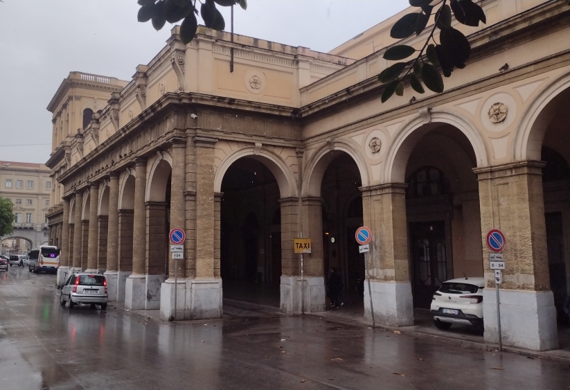
A port cochere is defined as a covered entrance large enough for vehicles to pass through. They were a regular enough feature for public buildings of scale in the 19th century, allowing horse drawn traffic to enter a covered area for unloading.
There is one at Heuston Station, which is a rather squat affair:
compared to that at the train station in Palermo, Sicily. The Italians must have had higher carriages.

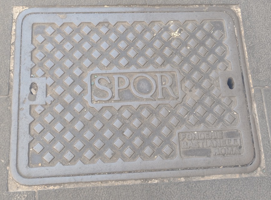
I was recently in Rome for the first time (a stopover before getting the train from Rome to Sicily) and noticed that many of the manhole covers in the streets had the initials SPQR cast into them.

For the uninitiated, this stands for “Senatus PopulusQue Romanus” in Latin, or “the Senate and the People of Rome” in English.
It is interesting to see the use of Latin in modern era infrastructure.
Castlecaldwell Station
I have created a page on the site containing old photos of Castlecaldwell Station in Fermanagh, which have been provided to me by Gabriel O’Connor, son of the last stationmaster at the station.
Many thanks to Gabriel for doing this and allowing me to include these on the site.
The Irish Examiner and Echolive.ie (the former has a soft paywall) have both reported on the discovery of archives of the Cork firm Johnson & Perrott, nowadays a car dealership but which started life in carriage manufacturing.
The archives have been donated to the Cork City Archives and there is apparently an exhibition about the company in the Cork Public Musuem, but I can find no reference to this on the latter’s website.
An alternative Collooney Junction?
I was looking at the historical OS maps online just now as the maps produced for the SL&NCR greenway consultation erroneously showed the SL&NCR taking a route from Collooney to Sligo that it didn’t (the map producers seem to have mistaken internal estate trackways for a railway trackbed). Anyway, that is not the subject of this post.
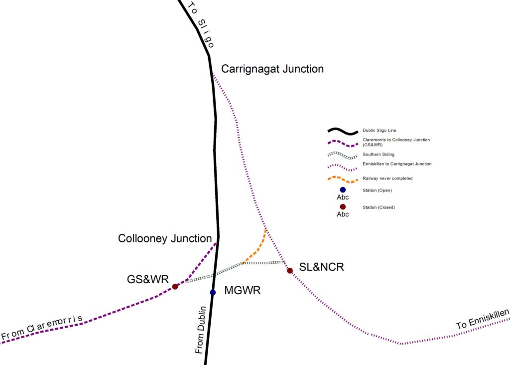
Collooney had an interesting set of junctions between MGWR (Dublin to Sligo), SL&NCR (Enniskillen – Collooney – Carrignagat Junction) and WL&WR/GS&WR (Claremorris to Collooney to Collooney Junction).
Looking at the 25″ OS map online, this shows a distinct railway trackbed like curve running from the GS&WR/SL&NCR link (the Southern siding) to the SL&NCR line from their Collooney Station to Carrignagat Junction which, if it had been completed, would effectively duplicate the line from the GS&WR Collooney line to Collooney Junction albeit some 400 feet to the east (see diagram below):

This would have been an interesting alternative to the GS&WR/MGWR connection – if it had been built, the SL&NCR would have received a cut of all traffic to/from Sligo that passed over the GS&WR line. This would have been an economic bonus for the latter, which was never very prosperous. As it so happens, this line did not come into existence and the closed but in situ connection from Collooney South station (GS&WR) to Collooney Junction (MGWR) happened instead.
Unfortunately it is not possible to link to the Geohive website – however, anyone interested in seeing this for themselves can go to www.geohive.ie, select Map Viewer an on the top right, select the option for “Zoom to Coordinate”. Enter the Easting as “567780” and the northing as “826994”. You will need to change the Basemap Gallery (top left) to “Map Genie 25 inch” and zoom out a bit.
Northern Ireland’s Mines
The BBC have a video article about mines in Northern Ireland.
The Conflict on Irish Railways
RTE has an article entitled “Enemy lines: the conflict on Irish Railways 1922-23” on their site, looking at aspects of Ireland’s railways 100 years ago.
A worthwhile read, I did notice an error in photograph selection, with RTE publishing a stock photo from SSPL/Getty Images, which they claim is of a Great Southern & Western Railway locomotive at Inchicore Works in Dublin.
I will be the first to admit that I have little to no interest in trains (including locomotives) and I know nothing about what type of locomotive this is or anything about it.
However, I did note that the initials on the side of the locomotive are:
“G&SWR” and not “GS&WR”.
A small difference, but significant in ruling this out as an Irish locomotive and also determining that the photo is not Inchicore.
There was a British railway company – the Glasgow & South Western Railway – the initials of which were “G&SWR”.