Categories
Site Updates

The Ulster Canal

I was up in South Ulster yesterday and the day before, doing a quick photographic update of the bridges/locks of the Ulster Canal. I didn’t manage to complete this as getting beyond Caledon on 12th July wasn’t possible, due to a 12th day demonstration in Killylea. A shout out to the PSNI officers manning the road block at Caledon who were bemused by this Dubliner telling them he didn’t know where he was going but was following instructions from Google!*

I plan to add the photos of the Ulster Canal to the site shortly. In advance of having this update to the site ready, below is a photo I took near to the end of the canal at Wattlebridge, of a boat on a trailer adjacent to the canalbed. I genuinely hope that this is the closest to the Ulster Canal this boat gets.
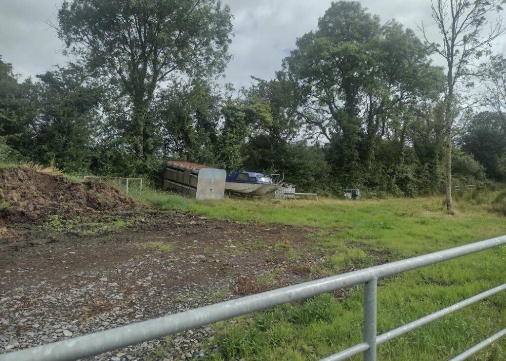
Boat beside dry Ulster Canal at Wattlebridge, Co. Fermanagh

* The process I use in cases like this is I identify all sites I need to visit on a given day and download the latitude/longitude co-ordinates of these, in the right order, into a spreadsheet and copy/paste the co-ordinates in sequence into Googlemaps on my phone, to navigate from one to the other.

Categories
History Site Updates

Keady Tunnel

The infamous Keady Tunnel in Co. Armagh never saw a train run through it, being built under the short lived Keady to Castleblayney railway line (1910-1923).

The reason for its existence was the Ulster and Connaught Light Railway – a madcap scheme to build a narrow gauge railway from Greenore, Co. Louth, to Clifden Co. Galway, via Newry, Bessbrook, Keady, Tynan, Maguiresbridge, Bawnboy Road, Dromod, Rooskey, Tuam and Cong to Clifden.

Some of this network would use existing railways but the most significant section from Dromod to Clifden would be entirely new. As this line was authorised around the same time as the line from Castleblayney to Armagh, the builders of the latter had to accommodate the proposal with a bridge under their line at Keady.

As the U&CLR plans never came to fruition, the tunnel has never had a train run through it.

I have created a webpage in the Gazetteer for Keady Tunnel and this (and other tunnels) will feature in the next map upgrade.

Categories
Site Updates

Update to the Gazetteer

The main feature of this site, that is a work in progress (due to the scale of what is required) is the Gazetteer. Currently, this is railway stations only but the long term plan is to cover all IH features.

One thing that has been holding me back is how to efficiently get information out of the master database I have developed over three decades of my interest in IH (stored in Microsoft Access). In the last week, I cracked this problem in relation to the creation of photo pages for the photos I have taken and placed online.

The other area I have been aware that my site was lacking in was presentation. The html pages are basic (largely hand coded html) without CSS and associated stylesheets.

I have now updated all stations (barring 2 minor stations) on the Dublin to Sligo line with a new format (using CSS) that I intend to roll out to all locations. The new photo gallery pages for each location are now a link to a separate page (see here for Mullingar as an example) for each photo, with a narrative explaining the image.

During the update of the pages for the Sligo line, I encountered a few errors in the data in my underlying database and these have also been corrected. This is a secondary benefit of this process.

It is my intention to continue the rollout of this new format across the site.

Categories
Site Updates Western Suburban

Western Suburban railway services

Irish Rail are currently seeking approval for a Railway Order to extend the DART to Maynooth or, more correctly, to 1 mile short of Kilcock.

For the uninitiated, the depot location included in this proposal is, for all intents and purposes, in Kilcock, being 1 mile short of the present Kilcock station. In fact, part of the plans for the depot include an emergency access onto Connaught Street in Kilcock, yet Irish Rail have been referring to this depot as the “Maynooth Depot” (having said that, in the actual Railway Order material online, the term “Depot” is used and not “Maynooth Depot”).

I have created this category, both to allow for posts about the progress of this project, construction updates (if authorised) and to advocate for service improvements to Kilcock and Enfield.

Categories
Site Updates

Rosslare railway stations

I am, as advised previously, currently updating pages in the Gazetteer to add in latitude/longitude references. All open stations are now updated and I have started work on closed stations on open lines.

Whilst doing so, I was looking at the photo I have online for one of the many stations to have existed in the Rosslare Harbour area and I think it is of one of the other stations.

I will be carrying out an exercise to fix this in due course.

Categories
Site Updates

Gazetteer new feature

I have started the process of changing the site information on the gazetteer pages, by removing the reference to the OS 1:50000 maps and adding in a latitude/longitude reference in its place. When traveling the country to photograph features, the latter is more useful for use in the likes of Google Maps.

So far, the two Kilcock stations are the only pages to be so updated – the rest of the open stations on the island of Ireland will follow shortly, with closed stations to follow after this.

Categories
History Site Updates

Castlecaldwell Station

I have created a page on the site containing old photos of Castlecaldwell Station in Fermanagh, which have been provided to me by Gabriel O’Connor, son of the last stationmaster at the station.

Many thanks to Gabriel for doing this and allowing me to include these on the site.

Categories
Site Updates

The Ulster Canal

Regular readers of this site know that I am opposed to the “restoration” of the Ulster Canal on both heritage and economic grounds.

I am back to being a lone voice in the wilderness on this one, since the passing of Brian J Goggin of irishwaterwayshistory.com 2 years ago.

In memory of Brian, whose contribution to the recording of the history of Ireland’s canals and navigable waterways far exceeded anything I have achieved, I have created a map of the Ulster Canal.

There are two larger scale maps linked off this – one covering from Charlemont to Lock 10 and the other from Lock 11 to Wattlebridge.

At the moment, these latter two are flat pages. However, I intend to add links off these to photo galleries for each feature, showing the canal as it remains today.

Categories
Locations Site Updates

Fairyhouse Halt

Located on the Clonsilla to Navan line between Dunboyne and Drumree stations, the halt at Fairyhouse was used for race day traffic for the racecourse of the same name.

When checking online aerial photos of the area today (both Googlemaps and Geohive.ie), I figured that I had the location wrong, in that I had assumed that the M3 motorway occupied the site of the line here. This is wrong – for a short section of line north of Fairyhouse, the M3 does occupy the former trackbed, but not at Fairyhouse.

The road overbridge at the halt was removed during motorway construction – however, the trackbed remains adjacent to the M3, including the halt site, which is now occupied by a garden attached to a private residence.

I have updated the Gazetteer page for Fairyhouse Halt and will add the photo of the site (a garden) in the near future.

Categories
Site Updates

Lagan Navigation

Last weekend was due to have been Heritage Open Days in Northern Ireland and I had booked to attend an event in Belfast as part of this.

As I also had a few stations on the Larne Line that I had not visited and photographed, I booked a B&B near Ballycarry with a view to using the excellent NIR Day Tracker (only available on Sundays) which allows all NIR network travel for the full day for £8.

Unfortunately, the event was cancelled due to an outporing of emotion over the passing of a person who, in a 1st world 21st century society, should not have the importance attached to her that she had.

As I had already booked my accommodation and train travel (up on Saturday and back on Sunday) I quickly drew up an alternative plan for Saturday, which took shape in the form of walking the Lagan Navigation from Lisburn back towards Belfast.

For various reasons, I only got from the point where the navigation disappeared under the M1 motorway back to Lambeg, however, I will be returning this weekend to walk from Lambeg back to Belfast.

In advance of posting the photos taken online, I have created a map of the Lagan Navigation (1st draft only) and this is online.